Número 69(2) • Julio-diciembre 2022
ISSN: 1011-484X • e-ISSN 2215-2563
Doi: https://dx.doi.org/10.15359/rgac.69-2.4
Recibido: 11/4/2021 • Aceptado: 1/10/2021
URL: www.revistas.una.ac.cr/index.php/geografica/
Licencia (CC BY-NC-SA 4.0)
Historical and geospatial reconstruction of a sector of the alternative route of the railway to the Atlantic (years 1871-1873), called: "Fajardo line", in a geographical area associated with the valleys of Orosi and Ujarrás, Cartago, Costa Rica
Reconstrucción histórica y geoespacial de un sector de la ruta alternativa del ferrocarril al Atlántico (años 1871-1873), denominada: “línea de Fajardo”, en un área geográfica asociada con los valles de Orosi y de Ujarrás, Cartago, Costa Rica
Iván J. Sanabria-Coto1
Investigador independiente, Costa Rica
Maureen A. Bonilla-Hidalgo2
Investigadora independiente, Costa Rica
Adolfo Quesada-Román3
Escuela de Geografía, Universidad de Costa Rica, Costa Rica
Abstract
This work consists of a historical and geospatial reconstruction, using Geographic Information Systems (GIS), of a sector of the alternative route of the Costa Rican Atlantic railway called: "Fajardo line", built between 1871-1873 and later abandoned. It was promoted by the government of Tomás Guardia Gutiérrez and executed by the North American contractor Henry Meiggs Keith. At the time, this work included, geographically, the north and west of the colonial valleys of Orosi and Ujarrás respectively, in the province of Cartago. This research covered the compilation of documents (historical), and geospatial inputs, as well as the identification, analysis, and integration, through GIS, of construction traces of civil works and evidence of associated anthropic activity, within the study area. As a result, it was possible to geospatially reconstruct the original railway route in the geographic sector of interest, through a reliable, methodological integration of the different identified evidence.
Keywords: Railway, reconstruction, heritage, Atlántico, Costa Rica.
Resumen
Este trabajo consiste en una reconstrucción histórica y geoespacial, mediante Sistemas de Información Geográfica (SIG), de un sector de la ruta alternativa del ferrocarril al Atlántico de Costa Rica denominada: “línea de Fajardo”, construida entre los años 1871-1873 y posteriormente abandonada. Esta fue impulsada por el gobierno de Tomás Guardia Gutiérrez y ejecutada por el contratista norteamericano Henry Meiggs Keith. En su momento esa obra incluyó, geográficamente, el norte y el oeste de los valles coloniales de Orosi y Ujarrás, respectivamente, en la provincia de Cartago. Esta investigación abarcó la compilación documental (histórica) y de insumos geoespaciales, así como la identificación, análisis e integración, mediante SIG, de vestigios constructivos de obras civiles y de evidencias de actividad antrópica asociada, dentro del área de estudio. Como resultado fue posible reconstruir geoespacialmente la ruta original del ferrocarril en el sector geográfico de interés, mediante una confiable integración metodológica, de las diferentes evidencias identificadas.
Palabras clave: Ferrocarril, reconstrucción, patrimonio, Atlántico, Costa Rica.
The geographical area of interest is to the east of the city of Paraíso, canton N° 2 of the Cartago province, forming part of the eastern limit of the Greater Metropolitan Area (GMA) of Costa Rica (Figure 1), including part of the valleys associated with past colonial populations of Orosi and Ujarrás.
Figure 1. Geographical location map, in CRTM05 coordinates, of the study area situated in the extreme southeast limit of the GMA of Costa Rica
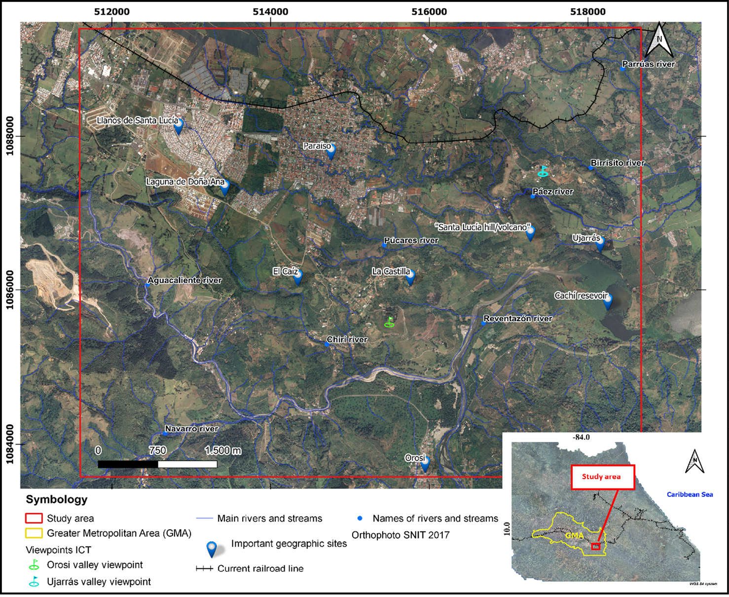
Sources: SNIT (2021), Ortiz and Montoya (2014) and own elaboration.
The specific study area is located to the south and east of the town of Paraíso in the province of Cartago (Figure 1); dominated by a variety of landforms characterized by valleys, flood plains and paleolacustrine plains (Ujarrás); that have been used in agricultural production, hydroelectric development and, as a whole, for natural tourist attractions of great scenic beauty.
It should also be noted the historical character of the area represented by the colonial ruins of the catholic church of Ujarrás and the temple and colonial convent of Orosi, declared a national monument and a historical-architectural monument, respectively (Figures 2.a and 2.b), located within the main population centers of each valley.
Figure 2. Ruins of the colonial church of Ujarrás (2.a) and colonial convent of Orosi (2.b), in their respective valleys.
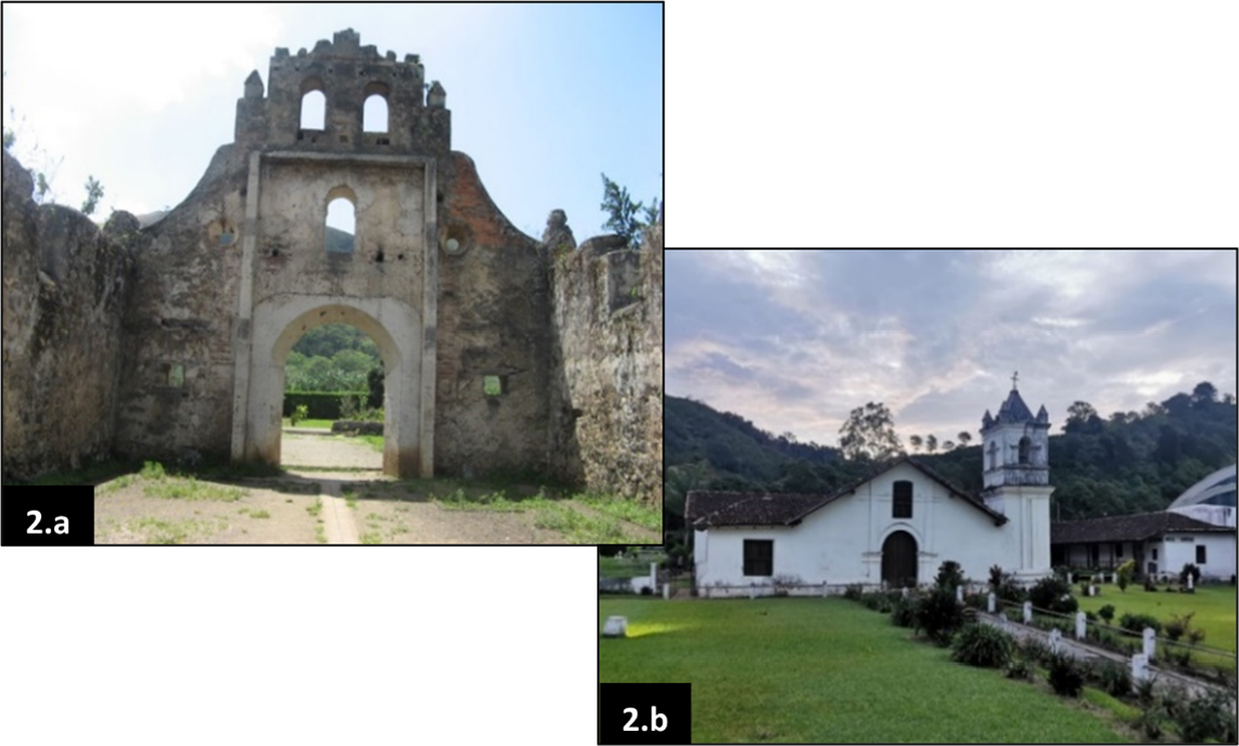
Sources: Photograph courtesy of Isaac Solano (Figure 2.b) and own elaboration.
Additionally, this research centers around the years from 1871 to 1873, during the first attempts and the almost immediate abandonment of the construction of the railway line to the Atlantic zone of Costa Rica.
Therefore, for the aforementioned period and within the study area (Figure 1), the construction of this route sought to facilitate access to the Atlantic zone of Costa Rica, since: “The 180-mile trip between San José and the Atlantic took 30 days, and for it different means of transport were used” (Quesada, 1983, p. 89).
In addition, according to Gutiérrez (1981), the North American contractor Henry Keith wished, for personal reasons, that the future rail line would descend when leaving Cartago, eastbound, as quickly as possible, reaching the upper level of the right bank of the Reventazón River (Figure 1), and continuing east, towards the Atlantic coast of the country. Furthermore, Núñez (1924) indicates that this route was based on the plan of one of the main engineers named M. Norris, who called it: “Fajardo line”, which crossed the Ujarrás Valley.
Regarding the above, Gutiérrez (1981) adds that, at that time, the line was drawn, the trail was opened, rails were even laid for some length, but upon reaching the "Lomas de Fajardo", very close to the current hydroelectric dam of Cachí, they ran into rock walls impossible to pass over, detour, or even pass through a tunnel.
From the foregoing, it can be inferred that the rapid abandonment in the construction of this alternate route of the Costa Rican Atlantic railway was, in large part, due to no, or little planning and design, this statement is supported by Murillo (1995), who adds that: the very layout of the railway route and the start, almost simultaneously, of the construction of the track from its two extreme points, in the Central Valley and the Port of Limón, was due more to political than technical decisions.
The latter is also reaffirmed by Gutiérrez (1981), by indicating that, as part of the usual trend in contracts for the construction of railway routes, the exact length or location of the track was not known, without an existing profile and without estimation of the number, size, as well as location of bridges, culverts, cuts, fillings, stations, possible tunnels, among many other aspects. In summary: "the construction process began from improvisation, rather than careful planning" (Rodríguez & Borge, 1979, p. 88).
Therefore, an objective of the present research is to show in an original and novel way a reconstruction of a part of the route for the railway to the Atlantic, carried out during the years 1871-1873, within the physiographic context of the study area.
Another objective associated with this work involves marking a milestone in the approach to this type of research to motivate the protection and promotion of the tourist and cultural value of the area of interest; therefore, at the end of this work the download link of the geospatial route of the proposed route is provided.
Theoretical-conceptual framework
First attempts at the layout and construction of the railway line to the Atlantic before the year 1871
For Peraldo and Rojas (1998), the idea of building a railway was already perceived as early as the 1820s advanced by the English miner Richard Trevithick, who had proposed to the Governing Board the construction of a railway that would communicate between San José and Limón; however, both authors add that it was during the second half of the 19th century that all efforts to build a railway intensified, as it was considered urgent or a priority for the country.
It is worth mentioning that, according to Hall (1976), the construction of the railway from Alajuela to Limón was feasible through foreign financing, migrant labor, the import of construction materials, rolling equipment and fuel, all of these were problems that concerned the contractors throughout the period 1871 to 1873.
On the other hand, for Peraldo and Rojas (1998) the route layout deserves special attention, since it was characterized by improvisation, where everything seems to indicate that the route was studied concomitantly with the opening of the trail, causing economic losses and technical problems during and after its construction. The authors also add that the pretext that prevailed for the lack of preliminary studies for the railway work could be explained by the government's distrust of contracts for this purpose.
However, for Quesada (1983) it was later in 1866 that the Government of President José María Castro Madriz hired the services of Franz Kurtze, who drew up a map of the first interoceanic route through Costa Rica.
For Rodríguez and Borge (1979), among the few studies carried out, the most important were those of the German engineer Kurtze (1866) who presented three proposals for a railway line crossing the geographic area between Ochomogo of Cartago, in the center of the country, to Puerto Limón on the Atlantic coast of Costa Rica.
Further, within this same area, shown in the map of figure 3, Murillo (1995) manages to differentiate geographically the subsequent construction periods of the railway to the Atlantic.
Figure 3. Interpretation map, in CRTM05 coordinates, of the routes proposed by Kurtze (1866) and of the subsequent construction stages (Murillo, 1995).
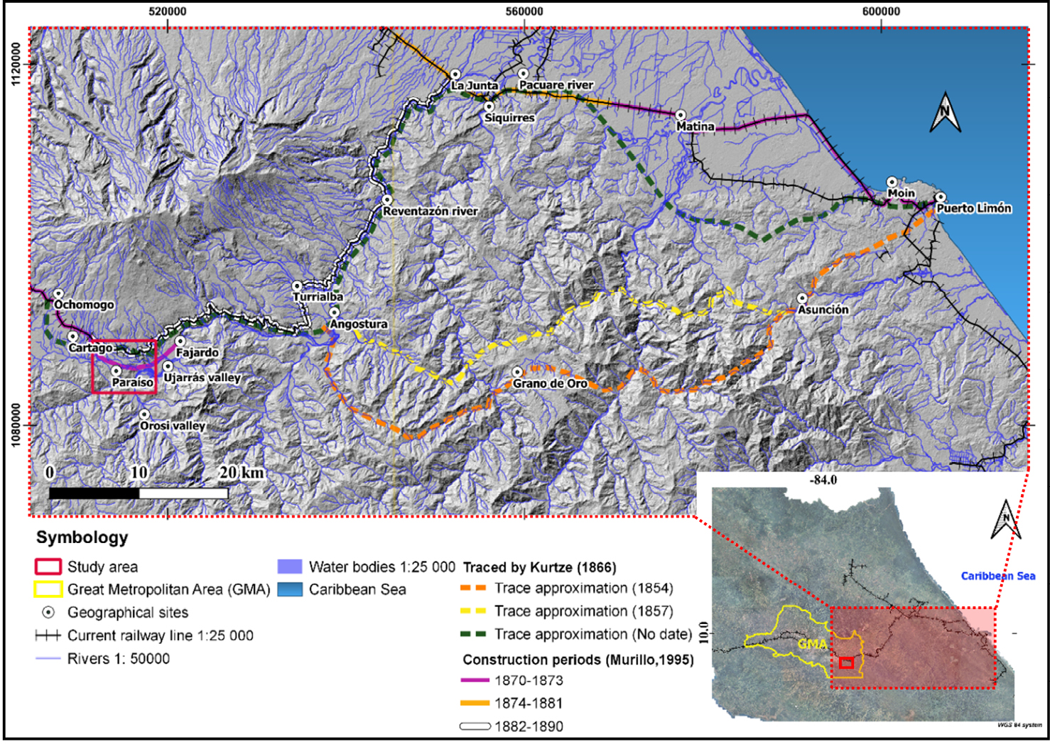
Source: Interpretations by Kurtze (1866), Murillo (1995) and altimetry from JAXA/METI (2011).
In the previous figure three approximations of the proposed routes to the Atlantic region of the country are observed, denominated as: “Line Survery”, with dates: 1854 (in orange), 1857 (in yellow) and undated (in green), the last route bears the greatest resemblance to the current route; however, within this proposal by Kurtze (1866), the railway route was located on the right bank of the Reventazón River, contrary to the current definitive route (left margin).
Signing of the contract for the year 1871 and works carried out for the construction of the railway to the Atlantic during the years 1871-1873, within the study area
After several attempts to finalize a contract for the construction of the Atlantic railway, Gutiérrez (1981) points out the vital entry to scene of the figure of Eng. Henry Meiggs Williams, also called the “Father of the Chilean railways”. However, for Macune (1982), it was the colonel and president of the republic, Tomás Guardia, who, after overthrowing the incumbent president Jesús Jiménez Zamora, gave the necessary thrust to the construction of the Atlantic railway.
Furthermore, according to Gutiérrez (1981) the contract with Keith was signed in Lima, Peru on July 20, 1871, which the signee transferred to his nephew Henry Keith (Henry Meiggs Keith), and the latter later included his younger brother, the 23-year-old Minor Keith.
For Quesada (1983), the Atlantic Division was initially arranged in three sections: “Limón-Pacuare” (38 miles), “Pacuare-Angostura” (28 miles), and the most important for the present research, “Angostura-Cartago” (28 miles), as seen in Figure 3. Therefore, for Quesada (1983), from the beginning it was perceived that the Costa Rican Atlantic railway was going to be an endeavor that would require enormous human, economic and engineering effort, this was palpable in the first six months of construction of the Atlantic Division, where some 4,000 men lost their lives, due to the poor sanitary conditions in the region.
It should be noted that the geographical area of study of the present research is related to the Atlantic Division, christened as such by Quesada (1983); however, based on Rodríguez and Borge (1979), Murillo (1995) and Casey (1976), this area corresponds specifically to a part of the Angostura-Cartago section (Figure 3), because, according to Rodríguez and Borge (1979), for the year 1872 the contractor company was organized into four work divisions of operational/logistical character, namely: I Division: Limón-Siquirres (Pacuare River), II Division: Siquirres (Pacuare River)-Angostura, III Division: Angostura-Cartago and IV Division: Cartago-Alajuela.
On the other hand, Gutiérrez (1981) mentions that, in a letter dated 1871, sent by Guillermo Nanne, general superintendent of the project, to Henry Keith, it is mentioned that the lack of engineers was a problem: “due to the short period during which the entire line should be built… from the beginning, the contractors improvised and began the construction of the line without having carried out the necessary preliminary studies by qualified engineers” (Gutiérrez, 1981, p. 87).
In addition, it was claimed that initially they had basically nothing: “no plan, no profile, actually no studies for track placement (line), much less field studies. Things were done in such a hurry at the beginning, that only little by little it was realized the many important considerations that had been forgotten” (Gutiérrez, 1981, p. 87). On the other hand, it was described that: "Our contractors are continually chasing engineers, not even giving them the time to study the terrain properly" (Hall, 1976, p. 112).
For Casey (1976), it was particularly in the sector between Angostura-Cartago, known as Division III, where worker camping sites were established, this due to a possible absence of densely populated centers, except for Cartago, in which workers could live, as well as the need to have them grouped in certain geographic areas to achieve better labor force management and easier supply of provisions to workers.
Furthermore, the aforementioned author points out that in principle there were five camps: # 1 in El Llano # 2 in Orosi, # 3 near Paraíso, # 4 in Ujarrás and # 5 in Fajardo. According to Rodríguez and Borge (1979), at the beginning of the works, 25 men departed from Paraíso (province of Cartago), where in October 1871, after 12 days of travel, they began work to open the forest, build warehouses, temporary houses, as well as temporary berths that would later be converted into iron piers 250 m to 350 m long. The inland railway line crossed virgin mountains and swampy areas that had to be filled with rock or brick.
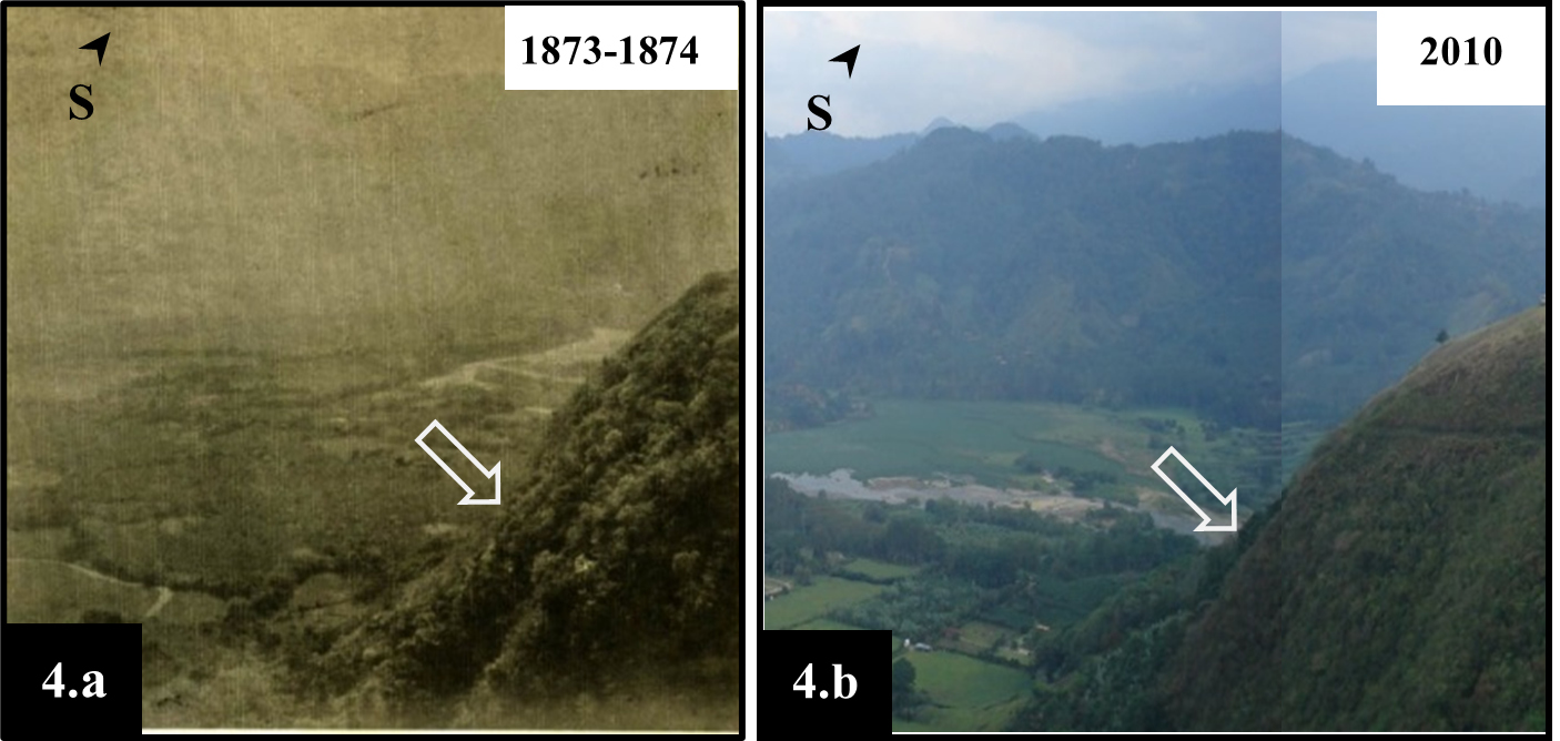
In historical photographs obtained from SINABI (2020) the high degree of vegetation cover existing in the Ujarrás Valley is visualized, for the years 1873-1874 (Figure 4.a) as well as for the year 2010 (Figure 4.b), which allows to understand the degree of natural complexity of the study area, specifically to the west of the Ujarrás Valley, through the so-called “Santa Lucía hill/volcano” (Sanabria-Coto & Bonilla-Hidalgo, 2021, p. 32).
Figure 4. View of the approximate sector (arrows) of construction of the railway line at the base of the “Santa Lucia hill/volcano” (Ujarrás) during the years 1873-1874 (4.a) and 2010 (4.b)
Sources: Modified from SINABI (2020) and own elaboration.
Both photographs (Figures 4.a and 4.b) were taken from the vicinity of the current Mirador de Ujarrás (translated as Ujarrás Viewpoint) operated by the Costa Rican Tourism Institute (ICT) (Figure 1), where it is possible, according to Sanabria-Coto and Bonilla-Hidalgo (2021), to appreciate the so-called “Santa Lucía hill/volcano” also known as: “Picacho”. The arrows (in white) indicate, approximately, the sector which shows evidence that construction work was carried out for the railway route.
Also for Peraldo and Rojas (1998) the absence of preliminary studies was quite evident in the case of the Reventazón Valley section in Ujarrás, since the Fajardo rocks were an insurmountable obstacle, investing the amount of one million pesos for the opening of the trail through lava and gaps without any positive results, the foregoing caused the abandonment of that section, specifically in the surroundings of Fajardo (Figure 3).
It is paramount to mention that:
although 5,000 miles of swampy land had been drained and reduced to 2,000 yards, malaria was rampant particularly among the Chinese population. The Cartago Hospital never had fewer than 150 Chinese sick with malaria. The impossibility of penetrating the mountains in the Fajardo vicinity made Henry Keith desist from the attempt, which resulted in a loss of one million pesos (Quesada, 1983, p. 95).
In addition, for Quesada (1983), Henry Keith (Henry Meiggs Keith), was only able to construct a total of approximately 48.5 miles, since on November 7, 1873 Keith no longer had the money that had been contributed by English moneylenders, therefore, it was decided to stop the operations, producing a violent response in the country; consequently, the government preferred to cancel the contract with Keith.
In summary, for Rodríguez and Borge (1979), at all times there existed a lack of definitive studies that would have made possible the assessment of potential topographic difficulties, the estimation of work delivery times, and the correct quantification of the financial and human resources required for the realization of the work. These authors add that some routes were decided on the fly, only to be discarded a short time later. Preparatory works prior to the construction of the line were carried out, however their fate was similarly short-lived and were abandoned soon after initiation.
Likewise, according to Quesada (1983), through the Soto-Keith Contract of April 21, 1884, Keith acquired the obligation to build the first section of La Junta-Cartago where the final and definitive route for the line between Limón and San José would be parallel to the left bank of the Reventazón River (Figure 3).
Finally, according to Rodríguez and Borge (1979), the construction process of the railway route to the Atlantic prolonged for at least 19 years. According to Quesada (1983) the historical milestone occurred on Sunday, December 7, 1890, with the departure of the first train with a direct trip from Puerto Limón to San José.
Physiographic context and its relationship with constructive activities for the adaptation of railway routes to the environment
In order to identify the possible constructive evidences of the construction of the railway line, it is necessary to understand the inherent physiographic context, such as geoforms, geological formations and their respective preponderant materials. The above has great impact on the strength and geomechanical properties of materials (geotechnics or geomechanics).
It should be noted that the importance of assessing the physiographic conditions prior to the construction of a railway line lies in the fact that:
Layouts for railway routes are considerably more demanding than vehicular roads (lower inclinations, greater radii of curvature, etc.) which determines lower degrees of freedom and the need to assume obstacles, natural or built, resulting in greater volumes of excavation, in the realization of a greater number of tunnels and in the definition of higher embankments and slopes. Alluvial zones are also frequently crossed, with the inherent problems of drainage and reinforcement of the foundation of the embankments (Campos, Castro & Santos, 1998, p. 117).
Considering the above, Campos et al. (1998) claim that the extension of the works complicates the rigorous evaluation of all the characteristics and parameters that condition the execution of a project that can be perfectly adapted to reality, specifically with the determination of the geotechnical characteristics of the materials involved. Additionally, the “extension of the works, the diversity and frequent heterogeneity of the associated materials make it difficult to carry out a definitive project, forcing to constant on-site intervention, readapting solutions whenever the more localized geological-geotechnical characterization suggests to do so” (Campos et al., 1998, p. 117).
On the other hand, according to Orme (2013), during England's rail craze of the 1840s many landslides of embankments and cuttings occurred because the safety factors required for different rock types were not well understood, which led to certain theoretical and practical investment in hillslope geomorphology.
Compilation of historical and geospatial information on the construction of the Costa Rican Atlantic railway, within the study area
In a first methodological stage of this research, an intensive compilation of information was carried out in the different formats (printed, electronic, graphic and audiovisual) available, such as: maps, plans, sketches, photographs, newspaper articles, profiles and topographic sections.
For the above, the databases of the following institutions were taken into account:
• National Archive of Costa Rica (ANCR).
• Documentation Center of the Supreme Electoral Tribunal (TSE).
• Publications of the Editorial Tecnológica de Costa Rica.
• National Library of Costa Rica.
• Municipal Library of Paraíso.
• Carlos Monge Alfaro Library of the University de Costa Rica (UCR).
• Luis Demetrio Tinoco Library of the UCR.
• Library of the Legislative Assembly of the Republic of Costa Rica.
Nonetheless, an evident methodological limitation was that, despite an exhaustive documentary search, it was not possible to obtain historical information on any pre-design that presented any relative degree of detail/scale or geospatial disposition to assist with a first geospatial approximation of the originally proposed railway tract corresponding to the III section, also known as the “Fajardo line”, in the study area for the years 1871-1873. Next, through QGIS® application, geospatial information of topographic, geological, geomorphological and hydrological nature was compiled and georeferenced (when necessary).
Two historical orthophotos from 1945, acquired at the National Geographic Institute (IGN) of the National Registry, were also processed. The importance in the choice of these aerial photos was based on their temporal proximity of 78 years (1873-1945) with respect to the date of construction, thus possibly guaranteeing greater conservation of field evidence, less vegetation cover and a lower density of new infrastructures than at present. However, their georeferencing implied new methodological limitations, due to the degree of error in the order of 10 m on average.
Likewise, free of charge current georeferenced orthophotos from the years 2005-2017, as well as free for use geographic information layers were employed in GIS platforms available in Costa Rican geoportals ascribed to the National Territorial Information System (SNIT). Online processing of satellite imagery was also performed using the Google Earth® platform. For use and analysis of the above inputs it was also necessary to download geoinformation from the repositories of the United States Aeronautical Space Administration (NASA), and of digital elevation models (DEMs) based on data collected by Synthetic Aperture Radar (SAR) systems and the ALOS PALSAR space sensor at 12.5 resolution. All of the above was complemented with panoramic field observation from natural overlooks (i.e., natural observatories) of the Orosí and Ujarrás valleys and surroundings (Figure 1), operated by the Costa Rican Institute of Tourism (ICT).
Elaboration of the geospatial proposal of the railway route to the Atlantic of Costa Rica, during the years 1871-1873, within the study area
By means of GIS, an integration, analysis and, finally, a geospatial correlation was carried out, by means of the free software QGIS®, of the compiled documentary information, georeferenced, as well as field observation data. With the above, it was possible to elaborate a proposal on the possible construction route of the railway, considering the following aspects:
• The landforms associated with their geomorphological classification (Van Zuidam, 1986) and their slope by means of a Digital Elevation Model (MED) of 12.5 m resolution.
• Geospatial integration on the physiographic context linked to geological and geomorphological information, as well as predominant hydrological elements within the study area.
• Discrimination of transit routes before and after the construction of the Atlantic railway during the years 1871-1873 in the study area, through analysis with GIS of historical orthophotos (1945) and based on the associated documentary information.
• Geospatial location of vector geometries associated with identified physical construction elements (civil works) in the field and mentioned in historical documentation.
• Identification and correlation, through GIS, of the greatest amount of evidence on alteration or anthropic adaptation of the possible route to the physiographic context of the proposed study area, such as:
- The transformation of gradients in the terrain, by means of earthworks, through constructive evidence of cuts, fills, ramps or elaboration of terraces and berms within the apparent built trails.
- Measurement, through GIS, of minimum widths in terraces built for rail transit.
- Identification of turning radii that are geometrically compatible with those built within the definitive route to the north of the study area.
- The determination and comparison of topographic gradients for the railway route proposed in this research, with respect to segments of the final route layout to the north of the study area.
- Geospatial correlation of construction works of logistical/operational nature, such as the approximate location of the workers’ camps, which have only appeared in the documentary information.
- Construction of hydraulic control works such as bridges, sewers and/or canalization, linked to the prevailing hydrology.
- Identification of elements related to the conservation of the route, such as retaining walls; as well as embankments to raise and protect the route in areas of steep slopes or fluvial interaction in the flood plains or alluvial fans at the bottom of the Ujarrás Valley.
- Through the application of GIS, the identification of different geographical areas with specific indications of relative geological instability and/or terrain erosion, initiated or accelerated by certain works and activities within the construction of the route.
As a result of all the above, it was possible to visualize, within the study area, at least three particular geographic zones that favored a first preliminary geospatial integration of the visible physical evidence (works); as well as those inferred by GIS, subsequently allowing the elaboration of a definitive map on the proposed reconstruction of the railway route for the years 1871-1873 within the study area.
Main characteristics of the physiographic context of the terrain and its relationship with the construction of the railway route (years 1871-1873), within the study area
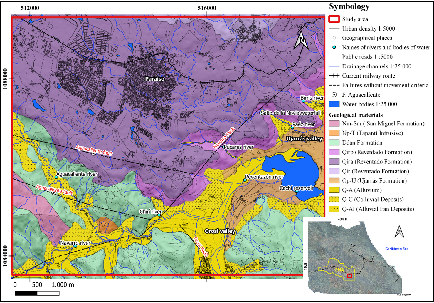
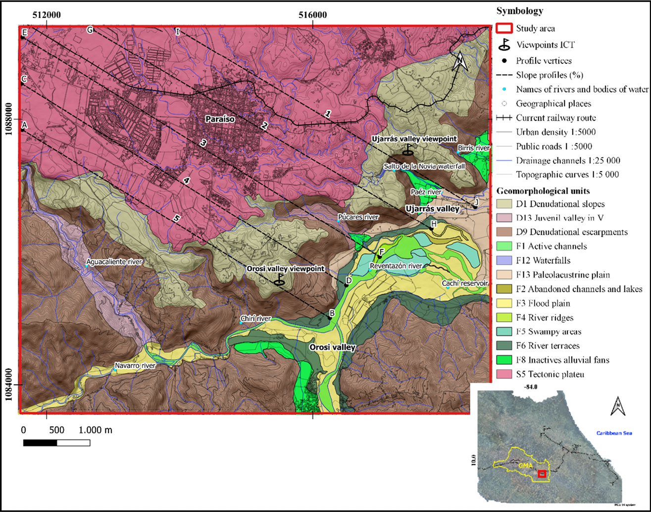
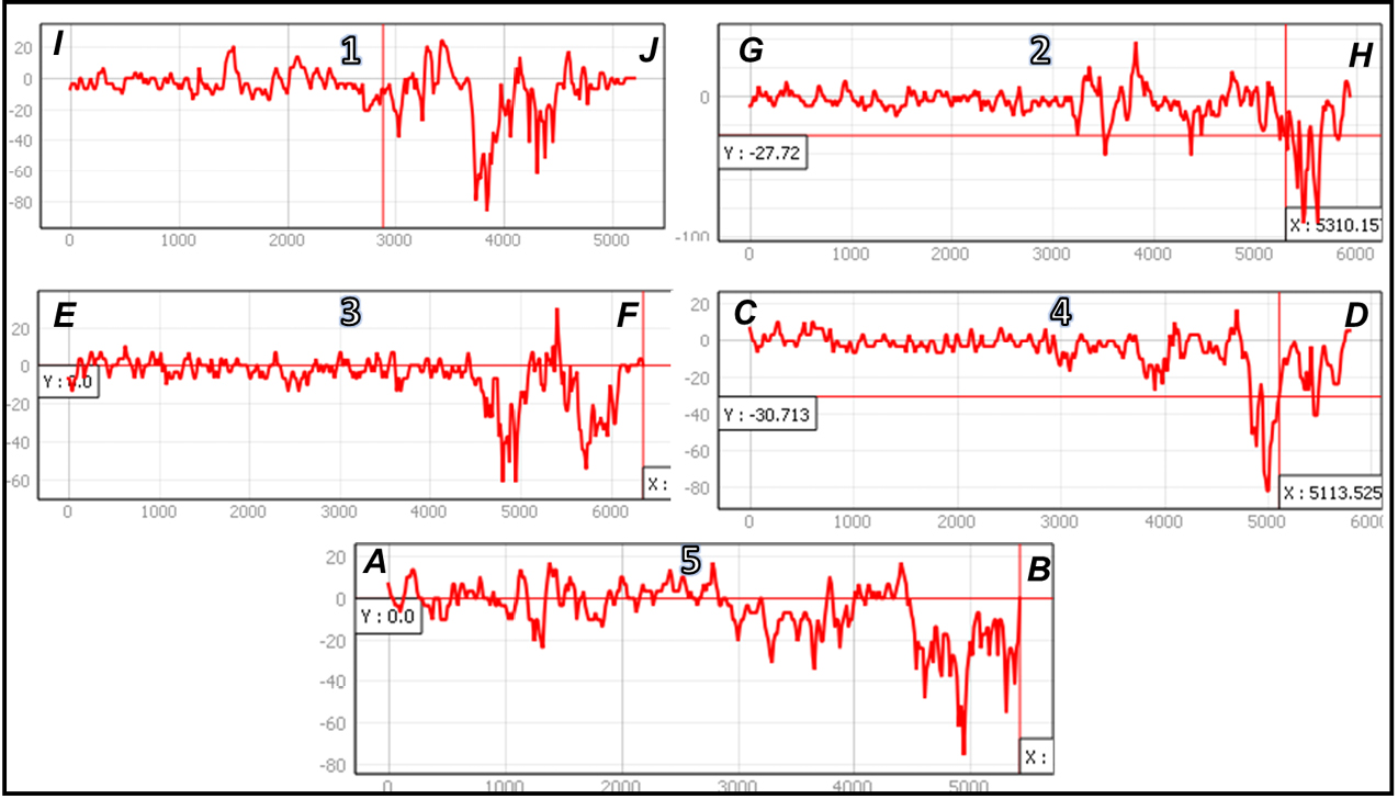
Based on the geospatial information compiled and integrated through GIS, geological (Figure 5) and geomorphological (Figure 6) physiographic characteristics were identified. In addition, five parallel profiles showing percentages of topographic relief were identified in the direction heading from the city of Cartago towards the Reventazón River in Ujarrás (northwest-southeast), being profile N°3, in the vicinity of the Púcares River valley, the one showing the lowest slope percentages (Figure 7).
Figure 5. Geological map of the study area in CRTM05 coordinates
Sources: Based on Krushensky (1972), Denyer, Montero and Alvarado (2009), JAXA/METI (2011), Sanabria (2014), Sojo et al. (2017), Sojo (2018) and own elaboration.
Figure 6. Geomorphological map of the study area in CRTM05 coordinates.
Sources: Based on Bergoeing and Malavassi (1981a, b), JAXA/METI (2011) and own elaboration.
Figure 7. Profiles with slope percentages (1-5) located on the map of Figure 6.
Sources: JAXA/METI (2011) and own elaboration.
Additionally, in the following comparative table (Table 1), the respective correlations between the physiographic context and the potential constructive evidences are shown.
Table 1. Correlations between the main geological/geomorphological characteristics and the possible evidences of the location of the railway route in the study area
|
Geological formation |
Main geological/geomorphological characteristics of the physiographic environment within the study area |
Types of evidence of activities or adaptations identifiable by GIS |
|
San Miguel Formation |
For Sojo et al. (2017) it is a geological unit composed of limestone. Within the study area it is located in the southwest extreme. Carballo and Fischer (1978) assign a geological age in the Lower Miocene-Middle Miocene. This formation is associated with denuded escarpments (D9) and marked topographic reliefs. |
In slightly weathered states, its handling requires the use of machinery and/or explosives in quarry-type work with predominantly vertical cuts and slopes. |
|
Tapantí Intrusive |
Sanabria (2014) describes it as blocks of great hardness of igneous rocks with phaneritic texture and a totally crystallized light gray matrix. It is located to the south and southeast of the study area. Alvarado and Gans (2012), assign them an age of 4.20 to 3.89 +/- 0.30 my 4.20 to 3.89 my. Geomorphologically, it is associated with denudational escarpments (D9), with high topographic reliefs. |
It has high resistance to manual handling in slightly weathered states, which is why it is necessary to use explosives and mechanized work in case of opening the way through predominantly vertical slopes. |
|
Doán Formation |
Sanabria (2014) describes it as lava and tuff, as well as clay matrix conglomerates. It is found predominantly to the south of the study area. For Alvarado and Pérez (1999) the age is from the Upper Pliocene. It is linked to denudational escarpments (D9), it shows marked reliefs and topographic slopes. |
Unconsolidated and/or heterogeneous volcanic materials make handling easier; however, in areas with high slopes there may be instabilities in the terrain, which is why cuts and/or vertical slopes are not feasible. |
|
Reventado Formation |
Krushensky (1972) classifies it as the Upper member of lava flows (Qir), followed by the Ash bed member (Qira) and the Lower member called Paraíso (Qirp) linked to the group of andesite lavas, which Sanabria-Coto and Bonilla-Hidalgo (2021) defined as andesites/basalts. |
The Ash Bed Member (Qira) presents the best handling conditions due to its high rippability, even manual, as a consequence of its low resistance and consolidation; however, this makes it susceptible to erosion and instability of the vertical cuts or slopes made, implying the accumulation of water and regolith in the horizontal cuts (berms), hence, the concentration of vegetation oriented transversely and horizontally to the respective hillsides. |
|
Reventado Formation |
This is the most preponderant geological formation from the center to the north of the study area, with thicknesses of 200 m for the lavas of the Paraíso Member (Sojo et al., 2017). Krushensky (1972) assigns the Reventado Formation a Late Pleistocene age. Also this formation presents an extensive tectonic plateau geoform (S5) from the middle to the north of the study area, generating areas of relative plains in the Paraíso and Cartago sector, with hillsides of gradual slopes (denudational slopes D1); as well as eventually abrupt slopes: Cascades and waterfalls (F12), such as the Salto de la Novia waterfall on the Santa Lucía “hill/volcano” (Figure 1), and denudational escarpments (D9), as there is an evident descent towards the valleys of Orosí and Ujarrás. There is also a marked topographic relief of this formation as it is dissected by the different rivers: Birrís, Páez, Púcares, and Chirí, which converge in juvenile valleys in V and parallel (D13) to the east, to the Reventazón river. |
On the other hand, the volcanic lavas of the upper members (Qir) and the Paraíso member (Qirp) present a greater geomechanical resistance to cuts and vertical slopes in predominant conditions of relative weathering that also allow the elaboration of aggregates and masonry for the construction of retaining walls, bridges and culverts on the route. However, adverse geomechanical conditions can occur due to tectonic fracturing, which implies the elaboration of protection areas or lateral support in sectors with almost vertical slopes. |
|
Ujarrás Formation |
Sojo et al. (2017), associated this formation with the lake deposits that make up the bottom or floor of the Ujarrás Valley. According to Sanabria-Coto and Bonilla-Hidalgo (2021) it is composed of blocks of decimetric conglomerates in floating contacts within a matrix of coarse sand. Escalante (1966) assigns it a Pleistocene age. Geomorphologically, a paleolacustrine plain (F13) is inferred, linked to this geological formation, which is evidenced in low topographic slopes. |
Potentially erodible over time, decreasing the record of evidence, as seen in the contacts of this formation with the hydrodynamics of the Reventazón River, near the ruins of the colonial church of Ujarrás. Handling may be manual but preferably using machinery. |
|
Alluvium (Q-A) |
For Sanabria (2014), they are terraces of quaternary deposits (of sand, clay, silt and blocks) along the following rivers: Grande de Orosi, Reventazón, Macho, Navarro, Juco, Blanco and Agua Caliente. For Sojo et. al (2017), the deposit lies mostly at the bottom of the wide Cachi reservoir. It has geoforms associated with active channels (F1), flood plains (F3), river ridges (F4), swampy areas (F5), abandoned channels and lakes (F2) and river terraces (F6), with low gradient slopes. |
There exists a relative resistance to erosion as a function of the number of clasts vs. sedimentary matrix. The associated materials can be used for aggregates in road embankments in flat areas, and/or as protection dikes in areas of strong river interaction subject to mass removal processes (floods and mud flows). |
|
Colluvial Deposits (QC) |
For Sanabria (2014) they are quaternary deposits with relatively consolidated materials and mainly composed of angular rock fragments (decimetric to metric), within a yellow clay matrix. In the study area they are located associated with topographic transition zones which "soften" the contrast of the upper relief with respect to the bottom of the valley. They are mostly composed of slopes with denudational slopes (D1), forming the foothills of the valley walls. |
Due to the geomorphological nature of altitude transition, as well as due to the relative consolidation and heterogeneity of materials, it is difficult to fully show cuts or slopes in these materials; however, the use of its materials as inputs and the use of its geomorphological characteristics, facilitated, in some sectors, the construction of gradual descents or ascents relative to the bottom of the valleys. |
|
Alluvial fan deposits (Q-AL) |
Sojo et. al (2017) point out that these materials occur in concomitance with deposits of colluvium and quaternary alluvium, which are associated with erosive/sedimentary geodynamics from the largest aligned escarpments. Furthermore, Sojo et al. (2017) add that the Ujarrás Valley has been exposed to mudflows with debris, linked to landslides, with evidence of eight fans, e.g., Paéz River. Therefore, the geoform of inactive alluvial fans (F8) corresponds to this formation, with a smoother slope of a piedmont and with a greater extension and longitudinal granulometric gradation than the typical colluvial deposits formed, mainly, by the action of gravity. |
These materials have similar characteristics to colluvial deposits (QC); however, due to the high degree of energy and speed associated with their formation, the preservation in time of all constructive evidence of a route through them is difficult due to the high possibility of destruction in periods of mud or rock flows. On the other hand, these areas can facilitate the construction of “sacrificial” approximation embankments or terraces between the bastions of bridges over active channels (F1). |
Source: own elaboration.
Identification and geospatial correlation of civil works in the field and of evidence inferred through GIS on the construction of the railway line to the Atlantic, between the years 1871-1873, within the study area
In order to discard those vestiges of civil works such as: bridges, slopes, retaining walls, cuts/fillings of roads, embankments, protection dikes, culverts, among others; that could be part of transit routes before or after the construction of the railway route (years: 1871-1873), an analysis was carried out within the study area, using GIS, of two historical orthophotos acquired at the IGN (1945).
Benavides (1999), mencioned previous transit routes and of utmost importance for the Ujarrás Valley that made possible to identify geospatially the transit routes pre-existing the years of construction of the railway route in the study area 1871-1873, known as:
1. “La ruta Real de Cartago” (translated as "The Royal Route of Cartago"), existing since colonial times.
2. “La ruta de la Palma” (translated as "The route of la Palma"), existing prior to the year 1828.
3. “La ruta del Calvario” (translated as "The calvary route"), existing since the 1840s.
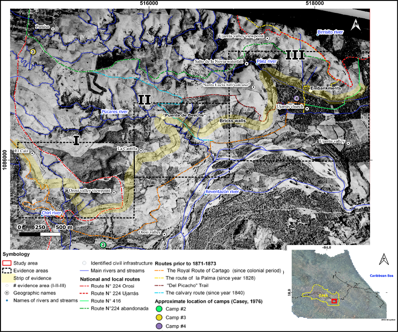
Also, the current national routes and some other relevant ones were identified, such as trails ("Del Picacho"), widely used and known by the population over time, all of which as a whole have served the populations as communication routes between the Ujarrás and Orosi valleys and other larger population centers to the west (Figure 8).
Figure. 8. Location of three evidence areas on the construction of the railway during the years 1871-1873 of previous and subsequent routes within the study area
Source: Modified from IGN (1945).
On the other hand, on the map in Figure 8, three main geographical areas with vestiges of construction works and/or associated inferred evidence were also recognized, namely: evidence area I, north of the Orosi Valley in the vicinity of the ICT’s overlook, followed by evidence area II, located between La Castilla and the entire Púcares river valley; finally, evidence area III covers the west and the Ujarrás Valley.
In these three geographical areas, at least seven different types of construction evidence can be seen, including physical, by observable civil works, as well as that inferred by GIS, as a consequence of the alteration or adaptation of the route to the characteristics of the physiographic context:
Type 1 evidence: Homogenization or leveling of the topographic relief, on the profile of the route, through earthworks, with cuts and fills visible mainly through orthophotos and satellite images. This includes the visualization of radii of gyration that are geometrically very similar to the final railway track (north of the study area); it should be noted, a strong geospatial correlation of this type of evidence with materials of low geomechanical resistance, such as in the Reventado Formation with its Ash Bed Member (Table 1).
Type 2 evidence: Gradual smoothing of the topographic relief in the construction of the route, observed by GIS, as an adaptation or “parallelism” of the route with the topographic contour lines, in order to promote relatively controlled topographic gradients for the descent and ascent of valleys (Table 1).
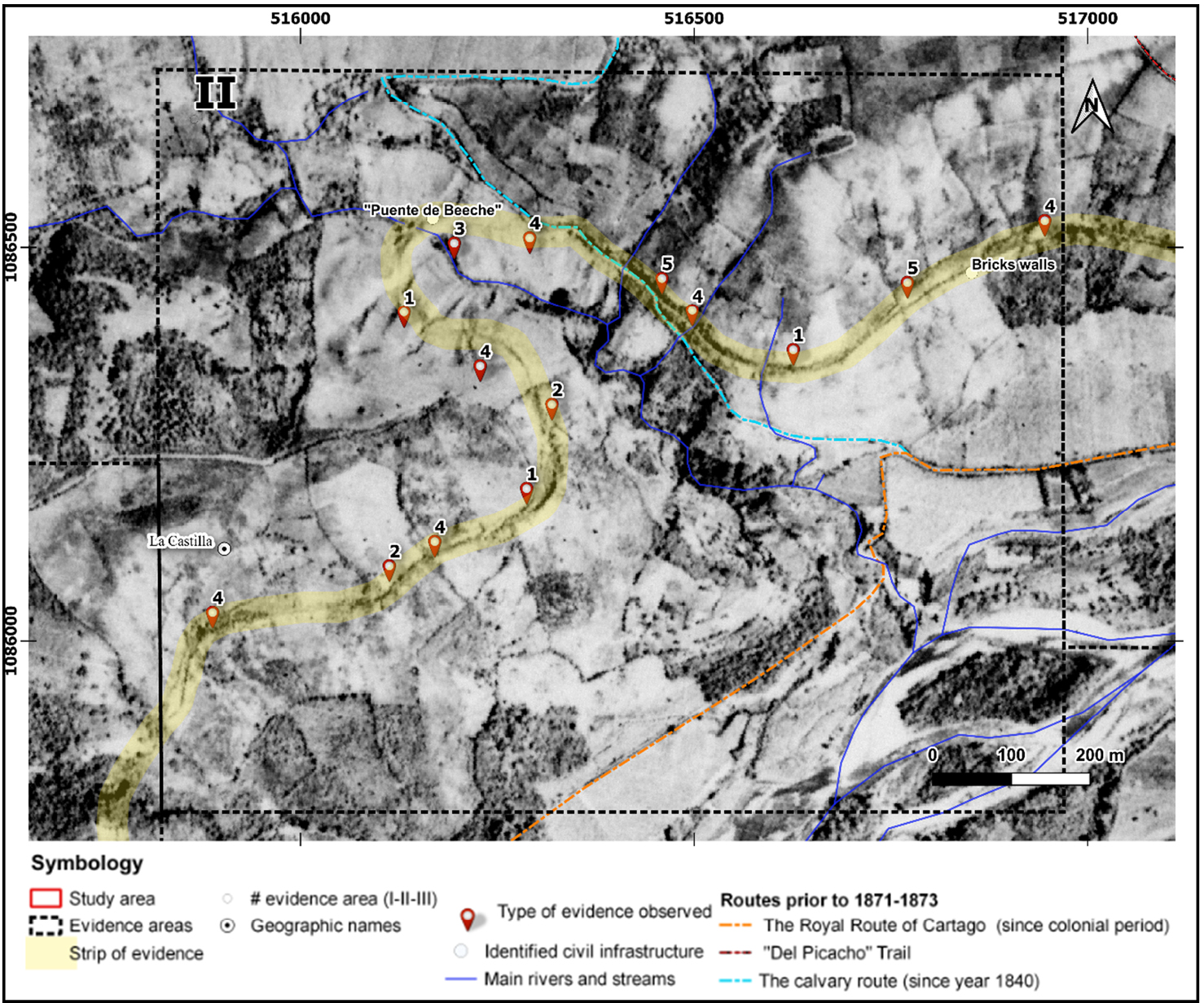
Type 3 evidence: Identification in the field and through historical documentation of construction remains (civil works) such as bridges (e.g. “Puente de Bechee”), culvert passages and retaining walls in rock masonry. An aspect of great interest in bridge “Puente de Bechee” is its exaggerated width, which is definitely associated with its location within the marked turning radius of the route at the bottom of the juvenile fluvial valley of the Púcares River; being therefore one of the few or possibly the only curved bridge of this type in the country.
Type 4 evidence: Strong evidence of erosion and enhancement of instability processes (landslides), a consequence of the transversal cuts of the topographic relief, in different geological formations, characterized by materials of low geomechanical competition, such as the Ash Bed Member (Qira) of the Reventado Formation. Also in other cases there is a greater growth of vegetation in horizontal cut zones for the width of the road or berms, which was favored by the reduction of the runoff typical of the original relief, causing accumulations of transported regolith and greater saturations of the terrain.
Regarding the above, Gonzales de Vallejo, Ferrer, Ortuño and Oteo (2002) point out that, in certain types of soils or soft rock massifs, the processes associated to weathering play an important role in reducing their resistant properties, which is why they can present intense alteration and degradation when the materials are exposed as a consequence of an excavation. In summary, this loss of resistance can lead to the fall of the surface material and, if critical areas of the slope are affected, it could generate general cracks, especially in conditions of presence of water.
Type 5 evidence: Visualization of vertical cuts on slopes, as well as the formation of narrow berms or terraces (<5 m) in conjunction with extensive retaining walls built with masonry directly in geological formations such as in the lavas of the Paraíso Member (high geomechanical competence), as identified in Table 1, but due to the high slope percent of its hillsides, it implies problems in establishing wide track gauges in a route.
Type 6 evidence: Topographic transition areas associated with: Alluvial fan deposits (Q-AL) and Colluvial deposits (QC), which geomorphologically and geomechanically offer “natural ramps or terraces” alternatives to or from higher topographies relative to the bottom of the valleys, as in the case of the Ujarrás Valley, furthermore, its geological materials offer ease of manual handling (with multiple workers) and do not necessarily require mechanization or the use of explosives.
Type 7 evidence: Evidence of a constructive adaptation of the route to the external geodynamics (fluvial) of the bottom of the valleys (Ujarrás), by means of embankments, for the lifting and control of the topographic profile of the route with respect to the flat relief, using Alluvium deposits (QA) as inputs, this as protection and conservation safeguards of the route against eventual floods and/or strong processes of mass removal and deposition (Alluvial fan deposits), from higher topographies, such as the case of the Páez River (Table 1).
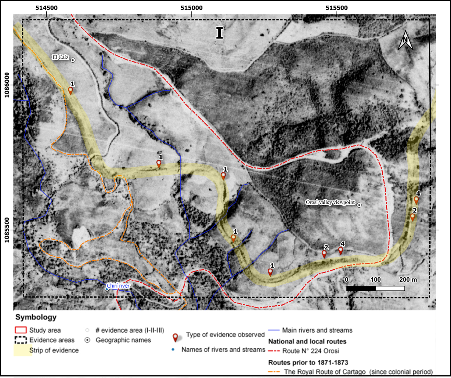
Next, it is geospatially visualized within the IGN orthophoto (1945), the location of the respective vestiges of construction or civil works that are observed in the field and/or mentioned in the historical documentation, as well as the evidence inferred through GIS, as a consequence of the alteration or adaptation of the characteristics of the physiographic context. For the latter, the previously described evidence classification was used, starting with evidence area I, southwest of the study area (Figure 9).
Figure 9. Evidence Area I, evidence numbering (1-7) within the study area is as described above.
Source: IGN (1945) and own elaboration.
According to Sánchez (2017), the line constructed between 1871-1873 departed from the Ujarrás Valley westbound, through the sector known as La Castilla, and continued through the Caíz sector until connecting with the section constructed to reach to Cartago; this last mentioned sector (Caíz) agrees geospatially with the first evidence area (I) (Figures 8 and 9).
On the other hand, it should be noted that in evidence area II, in addition to the identification through GIS of adaptive elements of ground work (Figure 10), there are physical construction vestiges (civil works) such as: bridges, culvert passages, and retaining walls in masonry, being complementary and necessary elements for a better adaptation of the route to the physiographic context of the study area, an example of this is the so-called “Puente de Bechee” over the Púcares River.
Figure 10. Evidence area II, evidence numbering (1-7) within the study area is as described above
Source: IGN (1945) and own elaboration.
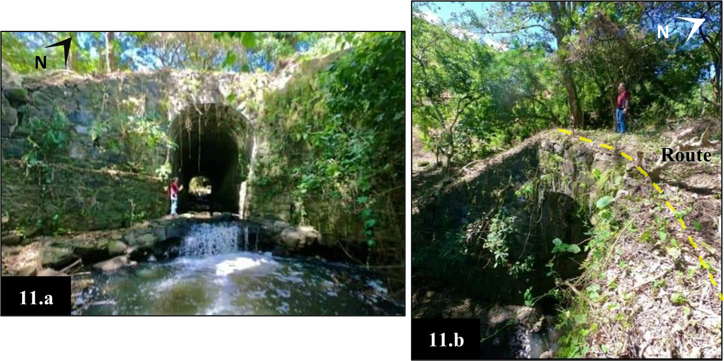
For Sánchez (2017) the bridge “Puente de Beeche” is built entirely with stone ashlars that occupy the entire wall, being a construction of a semicircular arch, with a pipe vault followed by length of 30 m having a 4.40 m wide arch base, 7.0 m high from the floor to the top of the arch, and greater than 3 m thick walls. This bridge is among the largest constructed in stone within the Paraíso region.
Additionally, it should be mentioned that:
In the third division, most of the work activities of skilled workers were devoted to the construction of bridges. It became necessary to hire several stonemasons responsible for providing the masons and laborers with granite blocks necessary for creating a good foundation of the bridges (Casey, 1976, p. 313).
The latter is exemplified in figures 11.a and 11.b, with a view of the “Puente de Bechee” built over the Púcares River, which, according to S. Barquero, has the year of construction engraved on the rock: 1872 (personal communication, September 19, 2021).
Figure 11. Site view of the bridge Puente de Bechee built in the study area, over the Púcares River (1.a), for the railway route overpass (11.b).
Source: Both photographs courtesy of Sergio Barquero Ramírez.
Similar civil works such as bridges and culvert crossings were built towards the north of the study area, a decade later, between 1881 and 1888, in the current railway route, where it is possible to evidence an architectural constructive design of "stone ashlars" such as that employed for the bridge Puente de Bechee, “in the Italian style of the time” (Gutiérrez, 2020).
On the other hand, in evidence area II there are also lateral supports or support walls, which consist of masonry walls with a rock exterior and a filled internal part (American Planning Association, 2001).
These walls were built with the same construction technique of "stone blocks" mentioned above, to support the overpass of the route. This is because, despite materials of high geomechanical competence (lava) exist in situ (Table 1), it is due to the high gradient of the natural slopes and fracturing (Navarro fault) that involved a difficult excavation to achieve stable and wide vertical cuts in track gauges of possible terraces or berms.
The constructive solution to the previous problem is observed in the field by means of impressive and extensive retaining walls or lateral support that extend for tens of meters with minimum heights of 4 to 5 meters (Figure 12.a). These walls contributed to create way for the railway route in sectors where the hillsides were made of volcanic rock and positioned almost vertically, allowing gauges or berms of 3 to 4 meters in length on average (Figure 12.b).
Figure 12. View of stone retaining (brick walls) (12.a) for the formation of berms or gauges of the railway route (12.b).
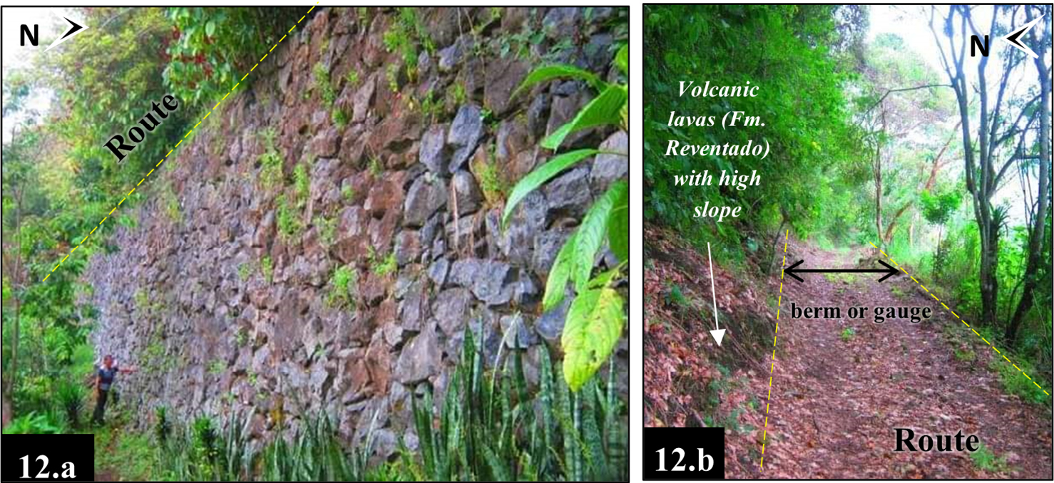
Source: Both photographs courtesy of Sergio Barquero Ramírez.
In addition, despite the good geomechanical conditions identified (Table 1), but nonetheless difficult to manage with the equipment of the moment, there are other physiographic elements such as tectonism linked to the Navarro fault trace (Figure 5), which implied higher levels of fracturing. In addition to the geomorphological characteristics, slope (Figure 6) and hydric conditions, collectively made difficult the construction of terraces with minimum horizontal gauges or berms directly in the volcanic rocks, for the future passage of the railway, in the volcanic rock hillsides south of the supposed Santa Lucía hill/volcano (Figures 1 and 10).
Additionally, regarding the above, Núñez (1924) points out that when starting the railway works it was initially thought to follow the southern route, enabling the plains of Ujarrás, but after realizing a moderate expenditure of capital on land filling, construction of sewers and bridges, the original idea was abandoned; today the layout of that period can still be seen in the ruins of brick walls present in evidence area III (Figures 8 and 13).
Figure 13. Evidence area III, evidence numbering (1-7) within the study area is as described above.
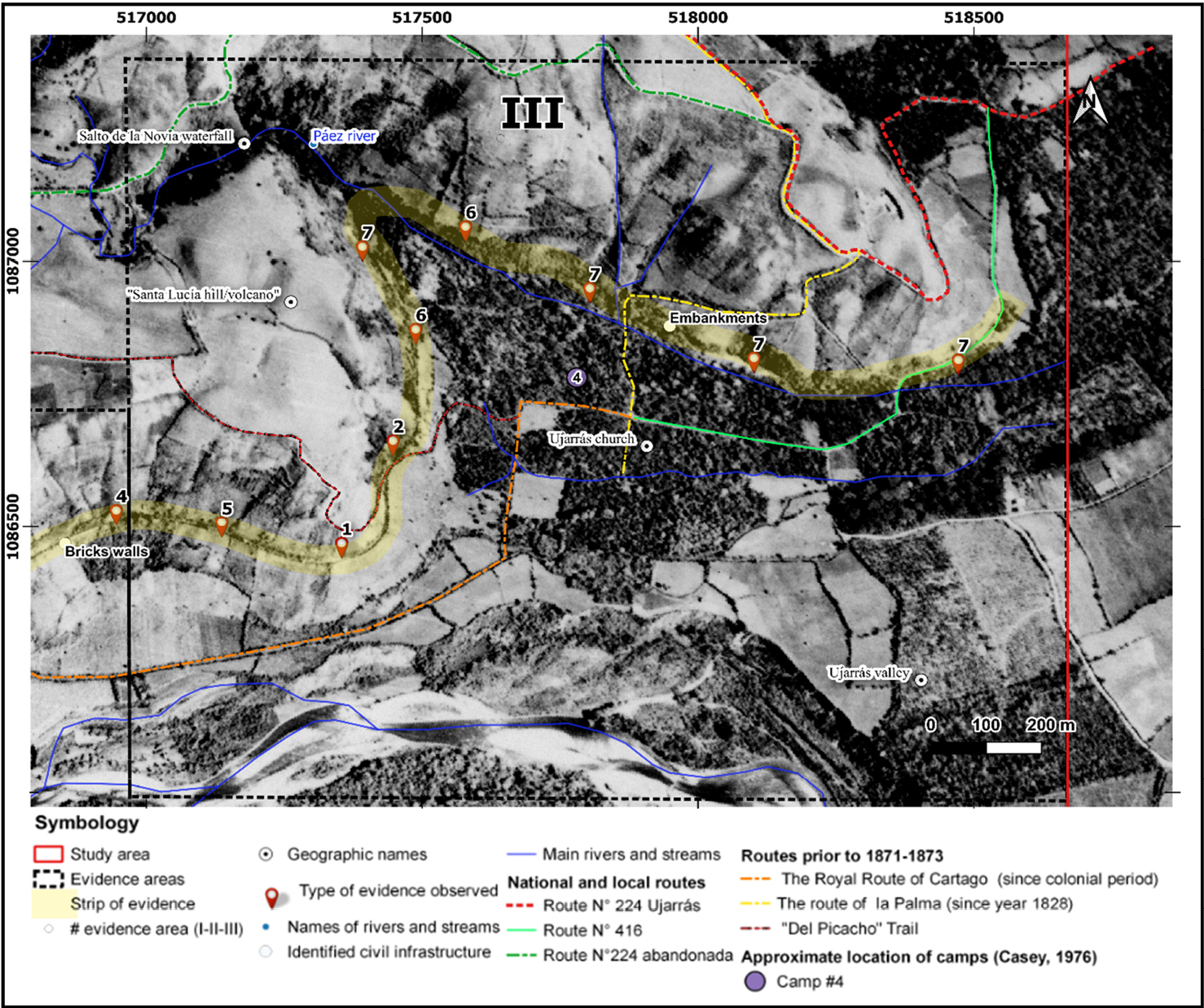
Source: IGN (1945) and own elaboration.
On the other hand, as indicated by Bolaños et al. (1993), the original section of the route from the Paraíso area continued eastwards, passing through the foothills of the Santa Lucía hills, towards the Los Novios or de la Novia waterfall or also called "Cascada Salto de la Novia", formed by the fall of the Paéz River at the bottom of the Ujarrás Valley (Figure 8), and from there the route headed towards Fajardo, where it is still possible to see the path known as “La Línea” as well as large roads, all these aspects seen in evidence area III (Figure 14).
Figure 14. Visualization, in the field, of cuts and formation of berms or terraces of descent/ascent on the eastern slopes of the “Santa Lucía hill/volcano”
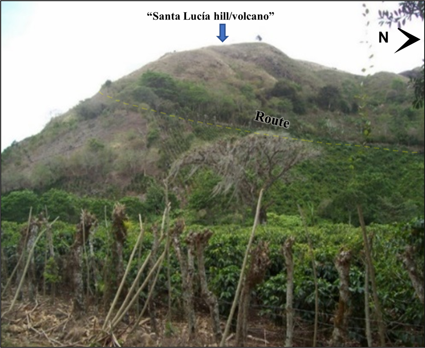
Source: Taken from Villalobos (2020).
In summary, for evidence area III, the geomorphological characteristics (profile 1 in Figure 7) were used to their maximum potential, to achieve a relative transition in the construction of the railway route from the abrupt and superior topographic relief to the Ujarrás Valley which is characterized by denudational escarpments (D9), specifically on the slopes of the supposed Santa Lucía hill/volcano and up to their contact with the bottom of the Ujarrás Valley (Figure 6).
Additionally, in the field, there is an evident use of construction material inputs associated with the Colluvial Deposits (QC) at the foot of the mountain (Table 1), located to the north of the valley and the town of Ujarrás through fillings (embankments).
The embankments elevate the route on the flat relief of the geoform of the paleolacustrine plain (F13) and, therefore, of the geological materials of the Ujarrás Formation, which are susceptible to erosive/sedimentary processes of fluvial origin (Table 1), with special emphasis on the Páez River, associated to the Alluvial Fan Deposits (Q-AL) of the map presented in Figure 5.
In addition, it was verified by both GIS and field observation the presence of evident cuts in the original slope and the formation of berms or horizontal terraces towards the north of the Ujarrás Valley, which are linked to the construction of extensive embankments (Figure 15.a), all as part of an adaptation to the terrain and protection of the future railway line (Figure 15.b) against the fluvial geodynamics of the valley floor.
Figure. 15. Transverse embankment at the foot of the slopes adjacent to the Ujarrás Valley (Figure15.a), with a comparative diagram of its function (Figure15.b).
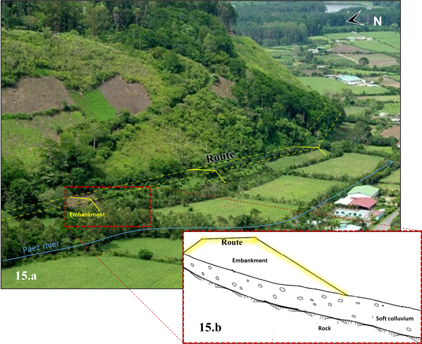
Source: Modified from VSat Center Co (2020) (Figure 15.a) and from Escario (1981) (Figure 15.b).
Definitive geospatial proposal for the route associated with the construction of the railway line to the Atlantic between the years 1871-1873, within the study area
Finally, traced over orthophoto obtained from SNIT (2021) it can be appreciated the definitive geospatial location of the railway route constructed during 1871-1873 proposed in the present research as the result of the integral inclusion of all the variables related to the topographic relief, the geological conditions, geomorphological characteristics, as well as all the identified constructive physical elements (civil works) in the field; and as a consequence of the identification by means of GIS of evidence of alterations or anthropic adaptations of the terrain (Figure 16).
Figure 16. Comparative image between both constructed routes, the southernmost corresponds to the alternative route of 1871-1873 while the definitive route is to the north of the study area
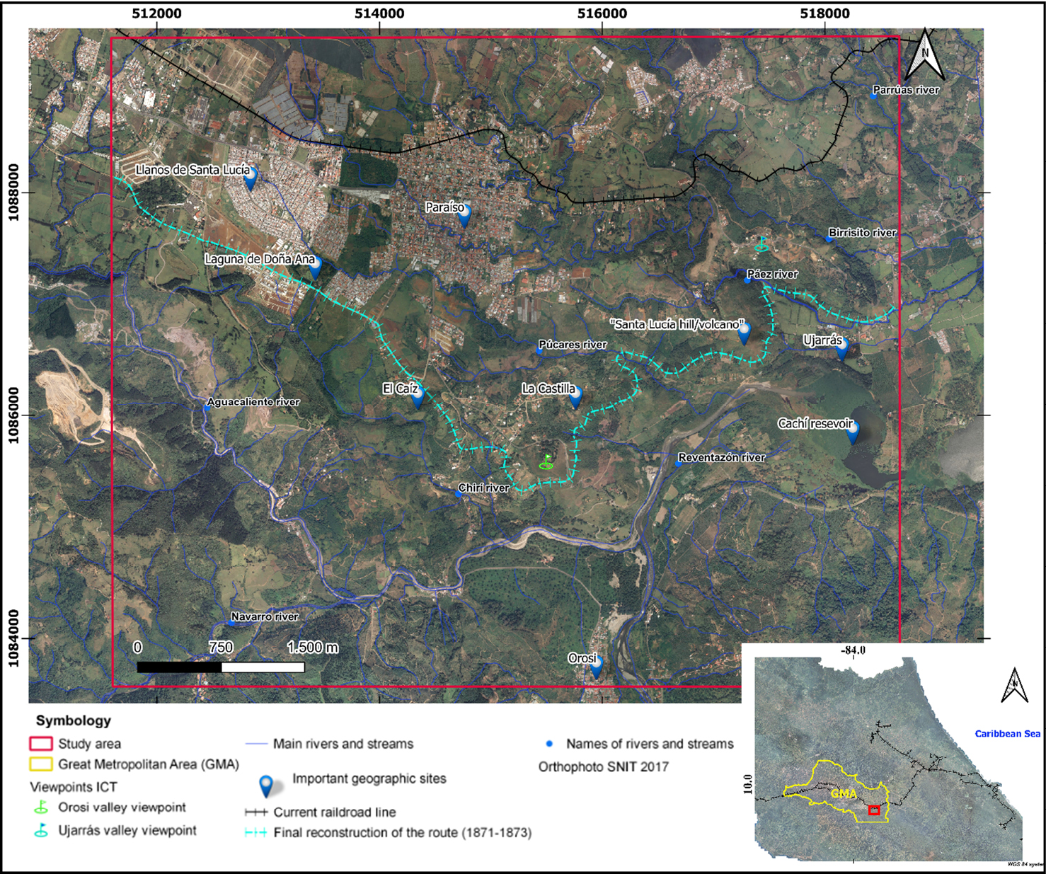
Source: Modified from IGN (1945) and own elaboration.
As part of the results of this investigation, it is verified that the construction of the aforementioned civil work, during the years 1871-1873, apparently had a deficient or non-existent design or planning stage that was compensated with pragmatism or constructive improvisation; which is reaffirmed in the lack of cartographic documentary information on the geospatial location of the approximately 10.6 km long section destined for the construction of the alternative railway route within the study area.
On the other hand, it is possible to clearly validate the methodology implemented in this research, based on the compilation of information, followed by a rigorous analysis of the characteristics of the geological and geomorphological context which aid in anticipating the possible adaptations or alterations of the construction work with respect to the materials from the geological formations identified. Also, of the respective associated landforms, in combination with the external and internal geodynamic processes of the area of interest (Table 1).
It is worth mentioning that, although there were methodological limitations in the spatial resolution of geospatial inputs, the degree of error in the georeferencing of orthophotos (when required) and the lack of historical cartographic information regarding the design and/or construction of the route, did not represent a major inconvenience, since it can be concluded that there was no difficulty in evidencing by means of GIS analysis the vestiges of anthropic activity directly linked to the construction of the railway within the study area during the years 1871-1873.
In addition, it was possible to perform an analysis of several profiles with slope percentages (Figure 6), from the NW sector of the study area in the direction of the city of Cartago towards the Ujarrás Valley (Reventazón River) towards the E and SE, which allowed identifying between profiles N°3 and 5 in figure 7 a geographic sector of interest located between the current Mirador de Orosi (translated as Orosi Viewpoint) and the juvenile fluvial valley of the Púcares River, this sector being the one originally chosen to guide (initially) the descent of the route from Cartago to the Ujarrás Valley.
Also, in the pragmatic vision of the contractors, the aforementioned geographical area was the one that could comply with a less abrupt topographic descent in the construction of the railway line, since Keith wanted: “for reasons that only he knew, that the future rail line would descend when leaving Cartago, eastbound, as quickly as possible, reaching the upper level of the right bank of the Reventazón Rivera, and continuing east, towards the Atlantic coast” (Gutiérrez, 1981, p. 88). This same idea was later reiterated by Minor Keith, Henry’s brother, when he said verbatim that "where a river rises a railway rises" (Peraldo & Rojas, 1998, p. 102).
Under the previous premise, the research focused, through GIS analysis, in the specific geographic sector mentioned above, being represented in figure 8 by the areas of evidence I and II, where clear traces of alterations and anthropic adaptations of the surface were identified, which enhanced, over time, the erosion/sedimentation processes and the consequent adaptation of vegetation that is still observed today through the historical analysis of orthophotos and aerial images.
Additionally, the visualization of civil works observed on field and/or mentioned by different authors such as: culvert bridges, retaining walls, embankments, as well as those that do not currently exist; but that, nevertheless, were of logistical/operational relevance, as was the case of the approximate location of camping sites.
All of the above as a whole made it possible to establish a first interconnection, geospatial and coherent, of the existing construction elements, as well as of the evidence of constructive and operational alterations/adaptations of the terrain. In addition to the above, architectural/constructive similarities were verified in the different vestiges, both physical and inferred, of the railway route built during the years 1871-1873, and the current route carried out a decade later to the north of the study area.
The similarities in the construction design of both rail tracks included percentages of topographic relief as well as minimum turning radii in the range of 45 to 65 meters for the reconstructed railway route compared to minimum turning radii of 25 to 80 meters in the current and definite route located to the north of the area of interest, specifically between the towns of Paraíso and Turrialba.
The foregoing was also applied in the identification and comparison of civil works in masonry and topographic adaptations of the route through earthworks and protection against the prevailing external geodynamic conditions. Ultimately, all this facilitated the identification and geospatial integration of all the elements in a final proposal of the constructed railway route.
On the other hand, an important result of this research was to highlight the historical and architectural background of the impressive engineering works in the study area, to make visible the tourist potential and the need to rescue the historical/cultural heritage of the canton of Paraíso and of Costa Rica in general. Regarding the above, and as a contribution in that sense, the proposed route for the railway during the years: 1871-1873 is included, in a geospatial format for viewing on the Google Earth ® platform (Kml): https://www.dropbox.com/s/47i51pyahsw32jo/Reconstruccion%20final%20del%20trazado%20%281871-1873%29.kml?dl=0
Additionally, it is expected that the present historical and geospatial reconstruction of the railway within the study area, originally built during the years 1871-1873, is a starting point for a tourism enterprise that can be promoted by the municipality of Paraíso and/or the private sector of the canton, taking advantage of the historical legacy and the great scenic beauty of the colonial valleys of Ujarrás and Orosi.
As a precedent, Sáenz (1911) had already mentioned that there was an initiative that was presented to Congress, which intended to take advantage of the investments of the civil works carried out as part of the construction and abandonment of the railway line in 1871-1873, to reduce costs in a future construction of a tram that would depart from the Orosí Valley, within the study area.
Finally, it is worth mentioning that, according to Granados and Morales (2019), among the main limitations for tourism development identified in the canton of Paraíso, it stands out the little use of the existing historical potential, an aspect that this research hopes to improve.
To the Editorial Tecnológica del Instituto Tecnológico de Costa Rica (ITCR), to the Documentation Center of the Supreme Electoral Tribunal (TSE), to Silvia Quirós from the Municipal Library of Paraíso for their kind cooperation in providing important historical texts for this research; as well as to the historian and priest Manuel Benavides, in addition, thanks are extended to Sergio Barquero and Isaac Solano for the photographs and associated information.
Lastly, a deep and eternal gratitude to the governments of the day that promoted this important work, but above all to all the brave people who gave their illusions, work and lives to carry out this human and technical feat; this investigation is dedicated to them with total humility and assiduity.
Alvarado, G. & Gans, P. (2012). Síntesis geocronológica del magmatismo, metamorfismo y metalogenia de Costa Rica, América Central. Revista Geológica de América Central, (46), 7-122. doi: https://doi.org/10.15517/rgac.v0i46.1836
Alvarado, G. & Pérez, W. (1999). The Doán formation (Pliocene) of Costa Rica: An overview on its description, origin, lateral equivalents, and further implications on the closing of the Central America seaway. Sixth International Congress on Pacific Neogene Stratigraphy and IGCP, 355: 150-167.
American Planning Association. (2001). Fundamentos de Planificación de Sitios. Recuperado de: https://www.planning.org/publications/document/9149225/
Benavides, M. (1999). De Ujarrás a Paraíso: análisis del traslado de una población 1821-1850, (Tesis de licenciatura). Escuela de Historia, Universidad de Costa Rica.
Bergoeing, J. & Malavassi, V. (1981a). Carta geomorfológica del valle central de Costa Rica. Hoja Tapantí, a escala 1:50 000 Map 3445 –III. Costa Rica: Ed. Inst. Geof. Nac.
Bergoeing, J. & Malavassi, V. (1981b). Carta geomorfológica del Valle Central de Costa Rica. Hoja Istarú, a escala 1:50000. Costa Rica: Ed. Inst. Geof. Nac.
Bolaños, R., Quirós, M., Alvarado, S., Quirós, E., Orozco, C., Solano, J. & Rojas, C. (1993). Ayer Ujarrás, hoy Paraíso. Texas: Ed. Servitex Flores, Universidad de Texas.
Campos, A., Castro, J., & Santos, P. (1998). Geotecnia ferroviaria-una experiencia reciente. Ferroviaria ‘98: Congreso Nacional de Ingeniería Ferroviaria, 115-128. Recuperado de http://hdl.handle.net/2183/10624
Carballo, M. & Fischer, R. (1978). La formación San Miguel (Mioceno, Costa Rica). Instituto Geográfico Nacional, informe semestral, septiembre, 45-144.
Casey, J. (1976). El ferrocarril al Atlántico en Costa Rica, 1871-1874. Anuario de Estudios Centroamericanos, (2), 291-344.
Denyer, P., Montero, W. & Alvarado, G. (2009). Atlas Tectónico de Costa Rica. San José, Costa Rica: Editorial Universidad de Costa Rica.
Escalante, G. (1966). Geología de la cuenca superior del río Reventazón, Costa Rica. Trabajos presentados en la primera reunión de geólogos de América Central. Instituto Centroamericano de Investigación y Tecnología Industrial (ICAITI) 1, 59-70.
Escario, V. (1981). Terraplenes y pedraplenes: estado actual de la técnica. Dirección General de Carreteras. Ministerio de Obras Públicas y Urbanismo. España: Ministerio de Obras Públicas y Transportes.
Granados, C. & Morales, G. (2019). Análisis del Potencial Turístico del cantón de Paraíso en el 2019, (Informe de la Práctica Profesional). Escuela de Ciencias Sociales, Instituto Tecnológico de Costa Rica.
González de Vallejo, L., Ferrer, M., Ortuño, L. & Oteo, C. (2002). Ingeniería Geológica. Madrid: Editorial Pearson.
Gutiérrez, H. (1981). La ingeniería en Costa Rica: 1502-1903 ensayo histórico. Cartago, Costa Rica: Editorial Tecnológica de Costa Rica.
Gutiérrez, F. (16 de febrero 2020). Un ‘error de ingeniería’: el puente-túnel de Ujarrás por donde nunca pasó el tren. La Nación. Recuperado de: https://www.nacion.com/el-pais/servicios/un-error-de-ingenieria-el-puente-tunel-de/X2ZHCXBHAND65KO7Z5SDGHD2DA/story/
Hall, C. (1976). Los archivos de Keith: algunos aspectos de la geografía histórica de Costa Rica. 1871-1873. Revista de Costa Rica, (11), 101-127.
Instituto Geográfico Nacional. (IGN, 1945). Proyecto: 732 4-M, Número de Rollo: 95 Número de línea: 1V-A, Número de sobre: 6, Números de fotos: 40 y 41, Año: 1945 Escala 1: 7 000.
JAXA/METI. (2011). ALOS PALSAR Hi-Res Terrain Corrected 2011 (AP 26652 FBS F0190 RT1). Recuperado de: https://www.asf.alaska.edu. https://doi.org/doi:10.5067/Z97HFCNKR6VA
Krushensky, R. (1972). Geology of the Istarú Quadrangle, Costa Rica. U.S. Govt. Print. Off., Geological Survey in 1358.
Kurtze, F. (1866). Informe La ruta ferroviaria interoceánica a través de la República de Costa Rica, 1866. Versión castellana de Ricardo Jiménez. Universidad de Texas. Costa Rica: Imprenta Nacional.
Macune, C. (1982). The Building of the Atlantic Railroad of Costa Rica, 1821-1891, (Tesis de maestría). Faculty of the school of Government of George Washington University.
Murillo, C. (1995). Identidades de hierro y humo la construcción del ferrocarril al Atlántico 1871-1890. San José, Costa Rica: Editorial Porvenir.
Núñez, F. (1924). Iniciación y desarrollo de las vías de comunicación y empresas de transportes en Costa Rica. Estudio sobre el desarrollo de carreteras y empresas de transporte como tributo al centenario del nacimiento del presidente de la República Jesús Jiménez. San José, Costa Rica: Imprenta Nacional.
Orme, A. R. (2013). Geomorphology for future societies. In: J., Shroder (Editor in Chief), A. R., Orme & D., Sack (Eds.), Treatise on Geomorphology (pp. 377-410). San Diego, CA: Academic Press..
Ortiz, E. & Montoya, C. (2014). Atlas Digital de Costa Rica 2014 [CD-ROM]. Instituto Tecnológico de Costa Rica. Escuela de Ingeniería Forestal.
Peraldo, G. & Rojas, E. (1998). La deslizable historia del ferrocarril al Caribe de Costa Rica. Anuario de Estudios Centroamericanos, 24(1-2), 97-128.
Quesada, R. (1983). Ferrocarriles y crecimiento económico: el caso de la Costa Rica Railway Company, 1871-1905. Anuario de Estudios Centroamericanos, 9(1), 87-119.
Rodríguez, A. & Borge, V. (1979). El ferrocarril al Atlántico en Costa Rica (Tesis de licenciatura). Escuela de Antropología, Universidad de Costa Rica.
Sáenz, M. (1911). Los Ferrocarriles en Costa Rica. San José, Costa Rica: Imprenta del Comercio.
Sanabria, I. (2014). Propuesta de modelo conceptual geotérmico de baja entalpia para el Valle de Orosí, Paraíso, Cartago, Costa Rica (Tesis de licenciatura). Escuela de Geología, Universidad de Costa Rica.
Sanabria-Coto, I. J. & Bonilla-Hidalgo, M. A. (2021). Interpretación geológica de las leyendas del cerro o volcán Santa Lucía al oeste del valle de Ujarrás, Paraíso, Cartago, Costa Rica y su relación con los elementos particulares de su contexto fisiográfico. Revista Geográfica de América Central, 2(67), 30-60. https://doi.org/doi: 10.15359/rgac.67-2.2
Sánchez, J. (2017). El Puente Beeche. El Paraiseño. Recuperado de: https://es.calameo.com/books/0038499877d7dad96b945
Sistema Nacional de Bibliotecas. (SINABI, 2020). Fotografías tomadas por el alemán Otto Siemon entre 1873 y 1874. Recuperado de: https://www.sinabi.go.cr/biblioteca%20digital/fotos/Fotografias%20de%20Otto%20Siemon.aspx#.X4vLi9BKjIV
Sistema Nacional de Información Territorial. (SNIT, 2021). Infraestructura Nacional de Datos Espaciales de Costa Rica. Recuperado de: https://www.snitcr.go.cr/#
Sojo, D., Denyer, P., Gazel, E. & Alvarado, G. (2017). Geología del cuadrante Tapantí (1:50 000), Costa Rica. Revista Geológica de América Central, (56), 83-116. https://doi.org/doi: 10.15517/rgac.v0i56.29238
Sojo, D. (2018). Geología de la hoja Paraíso (1:10 000), Costa Rica. Revista Geológica de América Central, (59), 101-124. https://doi.org/doi: 10.15517/rgac.v59i0.34161
Van Zuidam, R. (1986). Aerial photointerpretation in terrain analysis and geomorphologic mapping; with contributions from F.I. van Zuidam-Cancelado and other members of the International Institute for Aerospace Survey and Earth Sciences (ITC).
Villalobos, O. (2020). Fotografía de Camino a Ujarrás. Recuperado de: https://mapio.net/pic/p-9353393/
VSat Center Co. (2020). Fotografía de Valle de Ujarrás. Recuperado de: https://mapio.net/pic/p-15791956/
1 Investigador independiente. Máster en Gestión de Recursos Naturales y Tecnologías de Producción del Instituto Tecnológico de Costa Rica. Licenciado en Geología de la Universidad de Costa Rica. Correo electrónico: isanac81@gmail.com ![]() https://orcid.org/0000-0002-8281-298X
https://orcid.org/0000-0002-8281-298X
2 Investigadora independiente. Licenciada en Geología de la Universidad de Costa Rica. Correo electrónico: maureenbh2007@gmail.com ![]() https://orcid.org/0000-0003-0680-626X
https://orcid.org/0000-0003-0680-626X
3 Ph.D. Doctorado en Ciencias Ambientales por la Universidad de Ginebra. Escuela de Geografía de la Universidad de Costa Rica. Correo electrónico: adolfo.quesada@gmail.com ![]() https://orcid.org/0000-0001-6601-5254
https://orcid.org/0000-0001-6601-5254
Escuela de Ciencias Geográficas
Universidad Nacional, Campus Omar Dengo
Apartado postal: 86-3000. Heredia, Costa Rica
Teléfono: (506) 2562-3283
Correo electrónico revgeo@una.ac.cr
