
Morphometry of Toyogres river sub-basin, Cartago, Costa Rica
DOI:
https://doi.org/10.15359/rgac.60-1.9Keywords:
morphometry, Toyogres River, watershed.Abstract
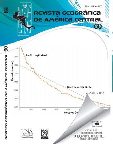
Based on geographic information systems and data modeling in Microsoft Excel, the morphometry of the Toyogres river sub-basin in Cartago was modeled. The purpose of the study was to develop the main geomorphometric and morphometric parameters that characterize a hydrographic basin as an initial stage in any hydrological study. The results showed how the shape of the sub-basin is related to the geometric aspects derived from the indices, which, therefore, responds to an elongated form. In turn, this form conditions the relationship of their drainage and the categories in which they are located.
References
Alvarado, G. (1993). Volcanology and Petrology of Irazú Volcano, Costa Rica. (Tesis Ph.D.). University of Kiel.
Alvarado, G.,; Carr, M.,; Turrin, B., Swisher, C., Schmincke, H. & Hudnut, K. (2006). Recent volcanic history of Irazú volcano, Costa Rica: Alternation and mixing of two magma batches and pervasive mixing. Geological Society of America Special Papers. 412, 259-276.
Alvarado, M., Durán, D., Fallas, K., Hernández, L. & Valverde, R. (2006). Amenazas y vulnerabilidad: El caso de los ríos Reventado y Toyogres, Cartago. Revista Reflexiones. 85 (1-2), 1021-1209.
Avinash, K., Deepika, B. & Jayappa, K. (2014). Basin geomorphology and drainage morphometry parameters used as indicators for groundwater prospect: Insight from Geographical Information System (GIS) technique. Journal of Earth Science. 25 (6), 1018-1032.
Boomfield, J; Bricker, S. & Newell, A. (2011). Some relationships between lithology, basin form and hydrology: A case study from the Thames basin, UK. Hydrological Processes. 25, 2518-2530.
Brooks, K., Ffolliot, P. & Magner, J. (2013). Hydrology and the Watershed Management. 4ta ed. Wiley-Blackwell.
Dade, W. (2001). Multiple scales in river basin morphology. American Journal of Science. 30, 60-73.
Demoulin, A. (2011). Basin and river profile morphometry: A new index with a high potential for relative dating of tectonic uplift. Geomorphology. 126, 97-107.
Esper Angillieri, M. Y. & Perucca, L. (2014). Geomorphology and morphometry of the de La Fecha river basin, San Juan, Argentina. Environmental Earth Sciences. 72 (8), 3227-3237.
Gordon, N., McMahon, T. & Finlayson, B. (2004). Stream Ecology: An Introduction for Ecologist. 2da edición. Wiley.
Jordan, G. (2007). Digital Terrain Analysis on a GIS Environment. Concepts and Development in Peckham, R., Jordan, G. (Eds). Digital Terrain Modelling: Development and Application in a Policy Support Environment. Springer.
Krushensky, R. (1972). Geology of Istarú Quadrangle, Costa Rica. United States Geological Survey Bulletin. 1358.
Langbein, W. (1947). Topographic characteristic of drainage basins. Water-Supply Paper. 968-C. USGS.
Méndez-Morales, M. (2012). Calibración y validación del modelo hidorlógico SWMM en cuencas hidrográficas de alta pendiente en Costa Rica. Tecnología en Marcha. 26 (2), 20-32.
Mikhailova, M. (2015). Morphometry of river deltas. Water Resources. 42 (1), 52-62.
Prabu, P., Baskaran, R. (2013). Drainage morphometry of Upper Vaigai river sub-basin, Western Ghats, South India using remote sensing and GIS. Journal Geological Society of India. 82, 519-528.
Moore, I., Grayson, R. & Ladson, A. (1991). Digital terrain modelling: A review of hydrological, geomorphological and biological applications. Hydrological Processes. 5, 3-30.
Newson, M. (1978). Drainage basin characteristics, their selection, derivation and analysis for a flood study of the British Isles. Earth Surface Processes. 3, 277-293.
Pareta, K. & Pareta, U. (2011). Quantitative morphometric analysis of a waterhed of Yamuna basin, India using ASTER (DEM) data and GIS. International Journal of Geomatics and Geosciences. 2 (1), 248-269.
Pavanelli, N., Capaccioni, B., Sarocchi, D., Vaselli, O., Tassi, F. & Duarte, E. (2004). Geology and stability of the southern flank of Irazú volcano, Costa Rica. Acta Vulcanológica. 16(1).
Pike, R. & Wilson, S. (1971). Elevation-relief ratio, hypsometric integral, and geomorphic area-altitude analysis. Geological Society of America Bulletin. 82 (4), 1079-1084.
PRUGAM. (2008). Plan Regional Urbano de la Gram Área Metropolitana de Costa Rica 2008-2030.
MIVAH-MOPT-MIDEPLAN-MINSALUD-INVU-IFAM-CNFL-AYA.
Racca, J. (2007). Análisis hipsométrico, frecuencia altimétrica y pendientes medias a partir de modelos digitales del terreno. Boletín del Instituto de Fisiografía y Geología. 77 (1-2), 31-38.
Ramírez-Granados, P. & Zúñiga-Mora, H. (2014). Modelado hidrogeológico para la caracterización de la hidrodinámica de las aguas subterráneas. Aplicación al acuífero de Cartago, Costa Rica. (Informe Final Proyecto 830-B2-039). Centro de Investigaciones en Ciencias Geológicas. Universidad de Costa Rica.
Shen, X., Vergara, H., Nikolopoulos, E., Anagnostou, E., Hong, Y., Hao, Z., Zhang, K., & Mao, K. (2015). GDBC: A tool for generating global-scale distributed basin morphometry. Environmetal Modelling and Software. 83, 212-223.
Strahler, A. (1952). Hypsometric (area-altitude) analysis of erosional topography. Bulletin of the Geological Society of America. 53, 1117-1142.
Taylor, A. & Schwarz, H. (1952). Unit-hidrograph lag and peak flow related to basin characteristic. Transactions American Geophysical Union. 33 (2), 235-246.
Villón, M. (2004). Hidrología. Editorial Tecnológica de Costa Rica.
Vittala, S., Givindaiah, S. & Gowda, H. (2004). Morphometric analysis of sub-watersheds in the Pavagada area of Tumkur district, South India usinh remote sensing and GIS techniques. Journal of the Indian Society of Remote Sensing. 32 (4), 351-362.
Zaidi, F. (2011). Drainage basin morphometry for identifyng zones for artificial recharge: A case study from the Gagas River Basin, India. Journal Geological Society of India. 77, 160-166.
Zăvoianu, I. (1985). Morphometry of Drainage Basins. Developments in Water Science. 20. Elsevier.
Downloads
Published
How to Cite
Issue
Section
License
Proposed policy for journals offering Open Access
Authors publishing their works in the Journal acknowledge and agree to the following terms:
a) Authors retain the copyrights to their works and guarantee the Journal the right to be the first to publish their works, under the Creative Commons License Attribution-NonCommercial-ShareAlike 4.0 International, CC BY-NC-SA 4.0 International (https://creativecommons.org/licenses/by-nc-sa/4.0/deed.es), which allows others to share works upon complying with the acknowledgment of authorship and mention of the Journal as the original publisher of the work.
b) Authors are permitted to separately establish additional agreements for the non-exclusive distribution of the official edition of the work published in the Journal (for example, authors may desire to place the work in an institutional repository or incorporate it into a book that is to published elsewhere) so long they acknowledgment to recognize the Journal as the original publisher. The aforementioned additional agreements must respect the terms of the non-profit character and sharing philosophy of the original license (CC BY-NC-SA 4.0 International, https://creativecommons.org/licenses/by-nc-sa/4.0/deed.es).
c) Authors are encouraged to archive the post-print or editor/PDF version in Open Access repositories.


 REVGEO is licensed under https://creativecommons.org/licenses/by-nc-sa/4.0/deed.es

